|
|
Product Reviews Garmin Nuvi 1300 LM Automotive GPS |
Back to Product Reviews Index |
|
|
Product Reviews Garmin Nuvi 1300 LM Automotive GPS |
Back to Product Reviews Index |
 |
Rating:: ☻☻☻☻K |
|
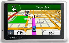
Note: I have updated this review several times, going from a negative first impression (2-smilies), through an acceptance (3-smilies), and now to an appreciation (4-smilies). There isn't an extensive user manual, but you can find out a lot by simply clicking through all the options. PRODUCT ACQUISITION DISCAIMER PRICE For techno-savvy users, the real comparison, in my opinion, should be against more powerful units and smart phones. Most smart phones have very capable GPS capability. So if you are in the market for a smart phone, check out its GPS capabilities - you might not need a stand-alone GPS - unless you are going to use it for aviation or marine purposes. MY EXPERIENCE HOW GPS WORKS SELECTIVE AVAILABILITY DIFFERENRTIAL CORRECTION ACCURACY THE GARMIN NUVI 1300LM The "LM" designation stands for "Lifetime Maps," which includes up to four free map updates a year. "Lifetime" means the life of the free updates - not necessarily your life or the life of the unit. The Nuvi 1300LM does not have differential correction, so its reading can (will) be off by yards. I went out on my back patio and tapped the screen icon that said "Where Am I" and it said I was at a house a half a block away. But at least it was on the right street, and even the right side of the street. Despite this error, it is quite good enough for street navigation. And the velocity and direction you are traveling will be even more accurate. When I drive up to my home, the unit's announcer is right on, or, close enough. LOCATION In civilization, the nearest address and nearest intersection are more useful, which display in the next two boxes down on the location screen. You can save the location displayed and give it a name. There are alo buttons for nearest hospitals, police stations, and fuel. ALTITUDE SPEED SIGNAL ACQUISITION BATTERY One way to circumvent this sunlight--battery-off link is to shield the unit from the sun with a thin plastic or paper hood over the unit. Paper or thin plastic won't interfere with signal acquisition. The lack of an external antenna option keeps the price low (relatively speaking), but reduces the unit's usability, especially for long trips. Unless you receive this model as a gift, do yourself a favor and look for a model that has an external antenna option. DISPLAY/SCREEN The Day mode is a white background screen, which, because it is white, uses battery faster. The Night mode is a black background screen, which because it is black, uses less battery. In my opinion, the Night mode (black background screen) shows detail better than the Day mode (white background screen) day or night. I use the Night mode all the time. Sunlight on the face of the unit makes the screen hard to read, you can increase the screen brightness (Tools/Settings/Display/Brightness) to compensate. Increasing brightness reduces battery life. You could make a little screen visor, or a hood, to keep the face shaded, and then keep the brightness reduced with a longer battery life. ROUTE PLANNING Fortunately, you don't have to input your starting point, only your destination. The unit knows where it is, as long as it is receiving a signal. All you have to do is tap "Go To" and select your waypoint (pre-stored as a favorite location). . WAYPOINTS Points of Interest in the database will already have a name, such a "Sea World." But addresses you input will usually not have a name. They will show up in the Favorites list as the house number and street name you input. To enter a name for a favorite address, follow these submenus: [Where To? >> Favorites >> (pick the waypoint you stored) >> Edit >> (input the name) >> Done]. Storing and naming waypoints (favorites) is fairly easy. You can assign a name to any waypoint (favorite) you save. TRACKING This feature only works when the unit is on, and it can easily be disabled by your errant spouse or child. If you want to play detective, your best bet is to give your errant one a smart phone that you have covertly subscribed to a tracking service. You can also track yourself manually by tapping TOOLS, then "WHERE AM I?", and storing the location as a waypoint (favorite), and giving it a name, such as T1, and subsequent points as T2, T3, ..., etc. This might be useful for trekking off road and storing the location of that neat waterfall or cave you discovered, or finding your way back on an unmarked trail. If you are going off-road, you want to set the mode to off-road, and store coordinates rather than addresses. The map, however, when you are off road, is useless to you, as it does not contain terrain features - and you can't use terrain maps with this model. ROUTE MODE Faster Time -- Restricted to major roads and limited access highways. Most people will use this setting most of the time. Shorter Distance -- Uses any road available. If you deviate from its chosen path, it will recalculate based on your present position. Less Fuel -- This will combine shortest distance with fewest traffic lights and stops. Off Road -- Here you will discover a quirk of automotive GPS units. The unit normally restricts you to the closest road or street, which masks the inherrent error so you don't see it. But when you select off road, your "trail" can be all over the place, because it has no error-correction mechanism. Example: I keep the trip log showing (a blue dotted line showing my paths traveled. When I turn into my garage, the path into the garage (about 25 feet) displays as a scatter of lines all over the map, as far as a block away. So don't expect a lot of accuracy in the Off Road mode. EVALUATION - this model does the basics well -- that is it gets you from point A (where you are now) to Point B (where you want to go.) It is accurate enough for street navigation. The text to voice works well, and announces turns well in advance, coming up on them, and when you are there. For most people, it does everything you want it to - for automobile traffic. You can zoom out on the map and see where you have been. And you can review the trip log (dotted blue line) to see where you have been, and how efficiently you drove. This model is still being sold, even though later models are available with a few more bells & whistles. Would I recommend this to a friend? Depends on the friend,
their budget, and their needs. For ordinary people wanting a little easy
navigation help on a budget - Yes, definitely. For techno-savvy explorers
wanting a do-all GPS -- No. For people with a smart phone -- Maybe. |
|
First posted 21 March 2012 at Amazon.com |
|
©2012 Simon Revere Mouer III, PhD, PE, all rights reserved